Kansas City Wakes to Flood Risk After Intense Overnight Storms
Kansas City residents are waking up to significant flooding concerns today after a powerful system brought heavy overnight rainfall, prompting advisories and a focus on road safety.
The Overnight Deluge: Anatomy of a Powerful Storm
What began as scattered showers quickly escalated into a formidable storm system that blanketed the Kansas City metropolitan area through the late hours and into early morning. Meteorologists had been tracking this system for days, noting its potential for heavy precipitation, but its overnight intensity still caught many off guard. The storm wasn't characterized by violent winds or widespread hail, but rather by its sheer volume of rainfall and its relatively slow movement. This combination meant that moisture-laden clouds lingered over specific areas for extended periods, relentlessly drenching the ground. Preliminary reports from various weather stations across the metro suggest rainfall totals easily exceeded three to five inches in many localized pockets, with some areas potentially seeing even more. These figures are particularly concerning given that the ground was already somewhat saturated from previous, albeit lighter, rain events earlier in the week.
The atmospheric conditions were ripe for such an event: ample moisture streaming in from the Gulf of Mexico, coupled with a stagnant frontal boundary that provided the lifting mechanism for the air to cool and condense. This created an efficient rain-producing machine. Thunder and lightning were persistent throughout the night, but it was the relentless downpour that truly defined this event. Flash Flood Warnings were quickly issued by the National Weather Service, covering numerous counties in both Kansas and Missouri as rivers and urban drainage systems struggled to cope with the sudden influx of water. The sheer intensity meant that storm drains, designed to handle typical heavy rains, were simply overwhelmed, leading to rapid accumulation of water on roadways and low-lying areas. The dark of night only compounded the danger, making it difficult for residents to assess the depth of rising waters until it was too late. This persistent, heavy rainfall is precisely the type of event that quickly transitions from a nuisance to a significant hazard, highlighting the vulnerability of urban environments to extreme precipitation.
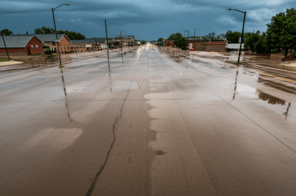
Widespread Impact Across the Metro: A City Under Water
The immediate and most visible consequence of the overnight storms is the widespread urban flooding. Commuters attempting to navigate their morning routes were met with numerous obstacles. Reports flooded local news channels and social media platforms detailing submerged underpasses, impassable streets, and vehicles stranded in rising waters. Major arteries like parts of I-35, US-71, and I-70 saw significant slowdowns and even temporary closures as emergency crews worked to manage the water levels and assist stranded motorists. Side streets and residential areas were particularly affected, with many cul-de-sacs and low-lying neighborhoods experiencing significant inundation, some seeing water creep towards or even into basements.
Beyond the roads, the extensive rainfall has placed immense strain on Kansas City's storm drain and sewer systems. While these systems are designed to handle significant precipitation, an event of this magnitude can push them beyond capacity, leading to water backing up and overflowing. This not only causes property damage but also raises public health concerns due to potential contamination from overflowing sanitary sewers. Local schools and businesses faced decisions about delayed openings or closures, impacting thousands of families and the day’s economic activity. Power outages, though not as widespread as during a severe wind storm, were also reported in scattered areas, primarily due to localized flooding impacting electrical infrastructure or downed tree limbs weakened by saturated soil. For a deeper dive into how this storm specifically impacted local news coverage and community response, you might find our previous report on the situation, "Kansas City Overnight Thunderstorms: KSHB 41 Weather Impact," particularly informative. This widespread disruption serves as a critical reminder of how interconnected our urban systems are and how a single weather event can ripple through various aspects of daily life.
Navigating the Danger: Essential Safety Measures for Residents
Given the current conditions, safety is paramount. Authorities continue to emphasize that the greatest danger during flash flooding is driving or walking through flooded areas. The ubiquitous advice, "Turn Around Don't Drown," isn't just a catchy slogan; it's a life-saving directive.
- Never Drive Through Floodwaters: Just six inches of moving water can knock a person off their feet, and a foot of water can sweep a vehicle away. Two feet of rushing water can carry away most cars, trucks, and SUVs. The depth of water can be deceptive, and the road beneath may be washed out. It’s impossible to tell if there are hidden hazards like debris, open manholes, or downed power lines.
- Avoid Walking Through Standing Water: Beyond the risk of being swept away, floodwaters can hide sharp objects, chemical pollutants, and electrical hazards. They can also contain raw sewage, making them a significant health risk.
- Stay Informed: Keep a close eye on local weather alerts from the National Weather Service (NWS) and trusted local news outlets. Many cities offer opt-in emergency notification systems. These resources provide real-time updates on flood warnings, road closures, and evacuation advisories.
- Prepare at Home: If you live in a flood-prone area, ensure important documents are secured and elevated. Have an emergency kit ready with essentials like water, non-perishable food, flashlights, a first-aid kit, and any necessary medications. If your basement is prone to flooding, consider moving valuables to higher ground.
- Check on Neighbors: Especially vulnerable populations like the elderly or those with disabilities might need assistance. A quick call or safe check-in can make a significant difference.
This situation in Kansas City echoes similar challenges seen in other regions recently, reminding us of the critical need for preparedness. For instance, our recent coverage on "Houston Weather Impact Alert: Heavy Rain & Storms" highlighted many of the same core issues and safety protocols. Adhering to these guidelines isn't just about personal safety; it's about minimizing the strain on emergency services, allowing them to focus on critical incidents.
The Forecast Ahead: Lingering Threats and Gradual Improvement
While the most intense rainfall has moved out of the Kansas City area, the immediate threat of flooding isn't entirely over. The National Weather Service cautions that rivers and creeks, already swollen from the overnight deluge, will continue to rise over the next 24 to 48 hours. Flood warnings remain in effect for several waterways, including segments of the Missouri River and its tributaries. Even if no more significant rainfall occurs today, the sheer volume of water making its way through the watershed means that some low-lying areas near these bodies of water will likely experience prolonged inundation.
The forecast for the remainder of the day and into tomorrow suggests a gradual improvement, though vigilance is still advised. Expect mostly cloudy skies, with only a slight chance of isolated, lighter showers in the afternoon. Temperatures are expected to remain moderate, which is a small silver lining as it prevents rapid evaporation that could add to humidity and discomfort. The focus for emergency management teams will shift from immediate rescue to damage assessment and recovery efforts. Road crews will be working tirelessly to clear debris, pump water from underpasses, and reopen affected thoroughfares. Residents should continue to monitor local advisories for updates on road conditions and water levels, particularly if their commute or daily activities involve areas near rivers or known floodplains. The saturated ground also means that the risk of tree fall is elevated, especially if any further wind gusts occur, as roots may have lost their anchorage in the softened soil. Recovery will be a multi-day process, requiring patience and continued adherence to safety guidelines.
A Look Back: Recent Weather Patterns and Broader Context
Kansas City is no stranger to severe weather. Its geographic location in the heart of the Midwest positions it squarely in "Tornado Alley" and makes it susceptible to a wide range of meteorological phenomena, from blizzards to blistering heatwaves. However, what stands out in recent years, not just for Kansas City but for many urban centers globally, is the observable trend towards more frequent and intense rainfall events. This isn't anecdotal; it's backed by climate science. Data from the National Oceanic and Atmospheric Administration (NOAA) indicates a clear increase in heavy precipitation events across much of the United States, especially in the Midwest.
Experts attribute this pattern, in part, to a warming climate. A warmer atmosphere holds more moisture, leading to the potential for more extreme downpours when conditions are right. This has significant implications for urban infrastructure. Many of Kansas City's storm drainage systems were designed decades ago, based on historical rainfall data that did not account for the intensity of today's extreme events.
"Our infrastructure was built for a different climate," noted a local city planner in a recent public forum. "We are seeing historical rainfall numbers that are pushing our existing systems beyond their design capacity, leading to more frequent and severe urban flooding."
This highlights a growing challenge: cities must not only respond to immediate weather crises but also adapt their long-term planning and infrastructure development to a new climatic reality. It's a complex interplay of meteorological shifts, urban development, and community preparedness that requires a multi-faceted approach. Understanding these broader trends helps frame the current flooding in Kansas City not as an isolated incident, but as part of a larger, evolving environmental narrative that affects metropolitan areas worldwide.
Community Resilience and Preparedness Initiatives in Action
In the face of these escalating weather challenges, Kansas City has been making strides in bolstering its community resilience. Local government agencies, often in partnership with federal programs, have been investing in initiatives aimed at both mitigating flood risks and enhancing public preparedness. These efforts extend beyond simply upgrading outdated storm drains, although that's certainly a part of it.
One key area is the embrace of "green infrastructure." This involves projects that mimic natural processes to manage stormwater, such as:
- Rain Gardens: Landscaped depressions that capture and absorb stormwater runoff.
- Permeable Pavement: Surfaces that allow water to filter through, reducing runoff into sewer systems.
- Bioswales: Vegetated channels that slow down and filter stormwater.
- Tree Canopy Expansion: Trees help absorb rainfall and reduce the urban heat island effect.
These nature-based solutions not only help manage water but also provide co-benefits like improved air quality and enhanced urban aesthetics. Furthermore, public awareness campaigns have been crucial. The city regularly promotes emergency preparedness, encouraging residents to sign up for alert systems, create family emergency plans, and assemble go-kits. There’s also a growing emphasis on community-level engagement, where neighborhood groups work together to identify flood-prone areas, share information, and even organize volunteer efforts during and after severe weather events. The goal is to shift from reactive responses to proactive readiness, fostering a culture where every resident understands their role in collective safety and adaptation. These ongoing initiatives are vital in turning the tide against the increasing pressures of extreme weather, ensuring that Kansas City remains a resilient and thriving place to live.
Looking Ahead: Long-Term Strategies for a Changing Climate
While immediate recovery from the recent overnight storms is the priority, the long-term outlook for Kansas City, and indeed many global cities, necessitates a robust strategy for adapting to a changing climate. The intensity and frequency of these rainfall events underscore the urgency of transitioning from reactive measures to proactive, sustainable urban planning.
Key components of a forward-thinking approach include:
- Comprehensive Infrastructure Modernization: This involves not just repairing but entirely upgrading aging stormwater and wastewater systems to handle greater capacities and integrate smart technology for real-time monitoring and management. It's a significant investment, but one that pays dividends in reduced damage and disruption.
- Zoning and Land Use Adjustments: Re-evaluating building codes and zoning laws to restrict development in high-risk floodplains, or requiring flood-resistant construction in vulnerable areas, can prevent future disasters. Promoting mixed-use developments that integrate green spaces can also help.
- Data-Driven Decision Making: Leveraging advanced meteorological modeling, hydrological data, and urban planning analytics can help identify critical vulnerabilities and predict potential flood impacts with greater accuracy, allowing for targeted interventions.
- Public-Private Partnerships: Collaborative efforts between city government, private businesses, and community organizations are essential. Businesses can contribute to resilience through innovative solutions, while community groups can amplify public awareness and preparedness efforts.
- Investment in Natural Solutions: As mentioned, expanding green infrastructure is crucial. Restoring wetlands, preserving natural floodplains, and increasing urban green spaces can significantly enhance the city's natural ability to absorb and manage water.
- Continuous Education and Communication: Ensuring residents are consistently informed about risks, preparedness measures, and long-term plans builds a more resilient and engaged populace. This ongoing dialogue helps manage expectations and fosters collective responsibility.
The overnight storms serve as a powerful reminder that adapting to new climate realities isn't an option; it's a necessity. By investing in resilient infrastructure, embracing sustainable practices, and fostering community-wide preparedness, Kansas City can continue to thrive, even in the face of increasingly challenging weather patterns.
Conclusion
Kansas City is currently navigating the immediate aftermath of a significant overnight weather event that has brought widespread flooding and disruption. While the heavy rains have subsided, the risk of standing water and rising river levels persists, urging residents to remain vigilant and prioritize safety. The response from emergency services has been swift, but the onus is also on individuals to heed warnings, avoid flooded areas, and stay informed through official channels. This event also serves as a potent reminder of the broader trend of increasingly intense rainfall events across the Midwest, highlighting the crucial need for ongoing investment in resilient infrastructure and community-wide preparedness. As the city moves from immediate response to recovery and long-term adaptation, the collective effort of residents, local authorities, and urban planners will be key to ensuring Kansas City remains a safe and vibrant place to call home.
Comments
Loading comments...